Ruamāhanga Aerial Hydrogeology Survey
Although this project holds a complicated name, the objective is simple: to identify a suite of sustainable water sources to better prepare for the projected climate change effects in the Wairarapa.
Critical work was undertaken in early 2023 to better understand the extent, volume and precise depth of water supply available in the Wairarapa. This will help Greater Wellington Regional Council (GWRC) make better water management decisions in the future.
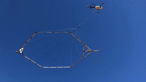
SkyTEM used a helicopter to fly equipment over the Ruamāhanga Valley, scanning aquifers from the air with world-class technology that can detect water up to 200 meters underground. The survey technique used covered a relatively large area in a relatively short amount of time at an appropriate level of detail.
Aquifers are vital underground reservoirs of freshwater that sustain ecosystems and drinking water supplies. Their protection and sustainable management is essential for both nature and humanity.
A large amount of data was collected and will be processed by GNS Science to build a 3D map of the Ruamāhanga underground aquifers. Insights gained from this will help GWRC understand the interconnections between groundwater and surface water to make better water management decisions.
The severity of projected climate change effects for the Wairarapa means that immediate efforts are needed to identify a suite of sustainable water sources. The lack of water security has also prevented land use from shifting to higher-value horticultural cropping and has made it difficult to distribute sufficient water allocations to existing farming operations.
Kānoa adminstered $1.4 million of government funding through the Provincial Growth Fund (PGF) in support of this project.